
Trace a Collierville Street by Address
Street-by-street work in Collierville begins with the property, not a name list. The Shelby County Assessor and Register GIS connect a street number and name to a parcel. That parcel supplies the situs address, current owner, tax map, lot, subdivision, appraisal details, and deed links. From there, the Register of Deeds index can identify the current transfer and the seller before it. Town Development records can add a construction or project history. Older directory and newspaper sources are useful only after the address, legal description, and period have been narrowed.
Keep the street number, direction, street name, suffix, ZIP, and mailing city as separate notes. The Register specifically advises omitting direction and street type in its address field, so a search that fails as “N MAIN ST” should be tested as “MAIN.” Record both the form entered and the form that produces a result. City and ZIP do not appear on every recorded document, and a Collierville mailing city can sit outside the present Town boundary.
- Search the street number and name in Shelby Register GIS, then note the property address, parcel ID, tax map, lot, subdivision, and current owner.
- Pan the parcel map or test the next street numbers to see adjoining parcels. Check the displayed owner, owner mailing address, appraisal, year built, and linked record tools for each parcel separately.
- Open the current transfer in the Shelby Register deed index. Save the grantor, grantee, recording date, instrument number, consideration, and legal description.
- Use GoVoteTN Search By Address only to check an individual registration or precinct result. It is not a public tool for producing a street roster.
- For a past household, compare the street section of a suburban directory with an alphabetic listing, then use a census, newspaper, or probate record to test the time period.
Note: A parcel can identify a taxable owner, but a current owner name alone does not establish who occupies the property.
Search Collierville Street Directory Parcels
The Shelby County Assessor is the valuation custodian, while Register GIS is the practical street-browse tool. Register GIS visibly accepts street number and street name, owner name in FirstName LastName form, parcel ID, and tax-map ID. Its parcel detail can show the current owner, property address, owner mailing address, parcel ID, tax map, year built, lot, subdivision, plat book and page, dimensions, acreage, class, use, coordinates, appraisal, and tax district. The Assessor landing page links property and GIS searches, but its accessible page text did not expose a reliable current input-field list.
The following controls are the documented search fields for the street tools. They are useful when an ordinary address search misses a tract because the parcel is filed by number, map identifier, or owner name.
| Collierville street search | Field | Input | Use |
|---|---|---|---|
| Register GIS address | Street Number; Street Name | Text | Submit an address to select a parcel |
| Register GIS owner | Owner Name | Text | Use FirstName LastName format |
| Register GIS parcel | Parcel ID | Text | Use the exact parcel identifier |
| Register GIS tax map | Tax Map ID | Text | Use the county tax-map identifier |
| County parcel layer | OBJECTID, MAP, PARCELID, PARID, OWNER | Service query fields | The public REST layer supports query, paging, statistics, and distance functions |
See the Assessor property-search landing page before choosing its linked residential, commercial, personal-property, or GIS option.

The Assessor page is a starting point for a parcel and valuation record. Confirm the selected tract again in the Register GIS detail before using an owner or mailing address as part of a Collierville street directory trail.
Collierville Street Directory Records
Address-keyed sources in Collierville do not have the same scope. A deed documents a recorded transaction, while a property card describes a taxable parcel. A permit may date work on a structure. A voter record can confirm a registrant at a listed residence at the data date, with important limits. Treat the shared address or parcel as a bridge between these separate systems, rather than as proof that every field refers to the same person.
| Address record | Street key | What it can show | Access route |
|---|---|---|---|
| Assessment/property card | Situs, parcel, owner | Owner, mailing address, appraisal, class/use, and improvement data | Assessor property search and GIS |
| Register GIS | Address, parcel, tax map | Owner, parcels, lot/subdivision, year built, plat, coordinates | Public parcel viewer |
| Register deed index | Address, parcel, lot, legal description | Grantor/grantee, date, consideration, book/page, document type | Public property search; images and old books vary |
| Plats and subdivisions | Lot, block, legal description | Roads, easements, adjoining parcel clues | Register records and Town Planning maps |
| Permits and inspections | Property or project address | Project and approval history when releasable | Town Development or a request |
| Voter registration | Residential address and precinct | Registration status and district information | Individual lookup or Election Commission request |
The Register GIS disclaimer says its map data reflect the April 2019 certified tax roll and are not an exact survey or an exact legal ownership boundary. Use a recorded instrument and the legal description when the result must be checked more closely.
Note: A ZIP or city label is not guaranteed to appear in a deed, so use the parcel and legal description as well.
Browse Collierville Street Parcels
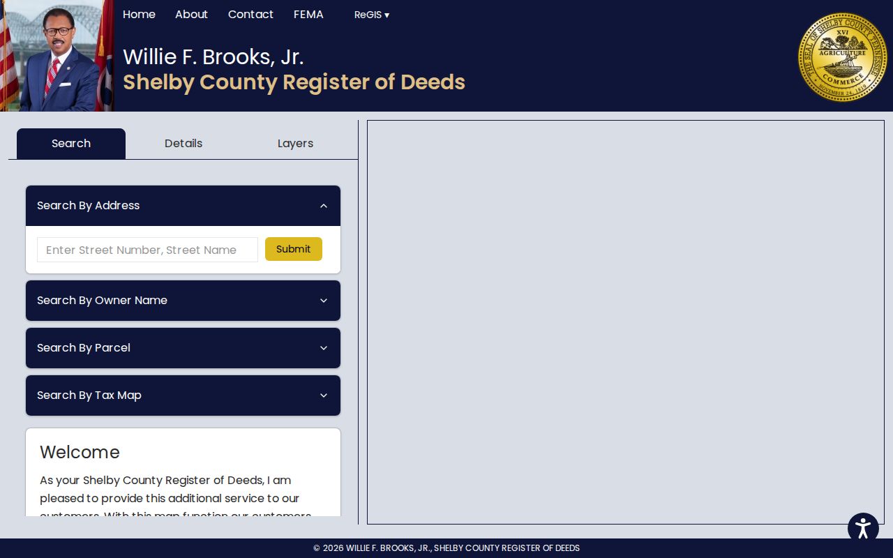
Once the right parcel is open, Register GIS helps make a street directory less abstract. The map displays surrounding parcels and has links for appraisal, city tax, county tax, recent property records, and historic aerials. A reader can pan and zoom to the parcels beside it, or search successive street numbers. The county parcel service also supports distance queries at the service level, although the public map’s exact on-screen buffer control was not documented. Do not describe a technical service feature as a public household-search tool.
The source image is the Shelby Register GIS parcel viewer, which displays the address, owner, parcel, and tax-map search paths.
Compare neighboring polygons only after confirming the street and parcel identifiers. A map boundary is a record-navigation aid, not a surveyed boundary or a complete record of who occupies each property.
Read Collierville Street Deeds
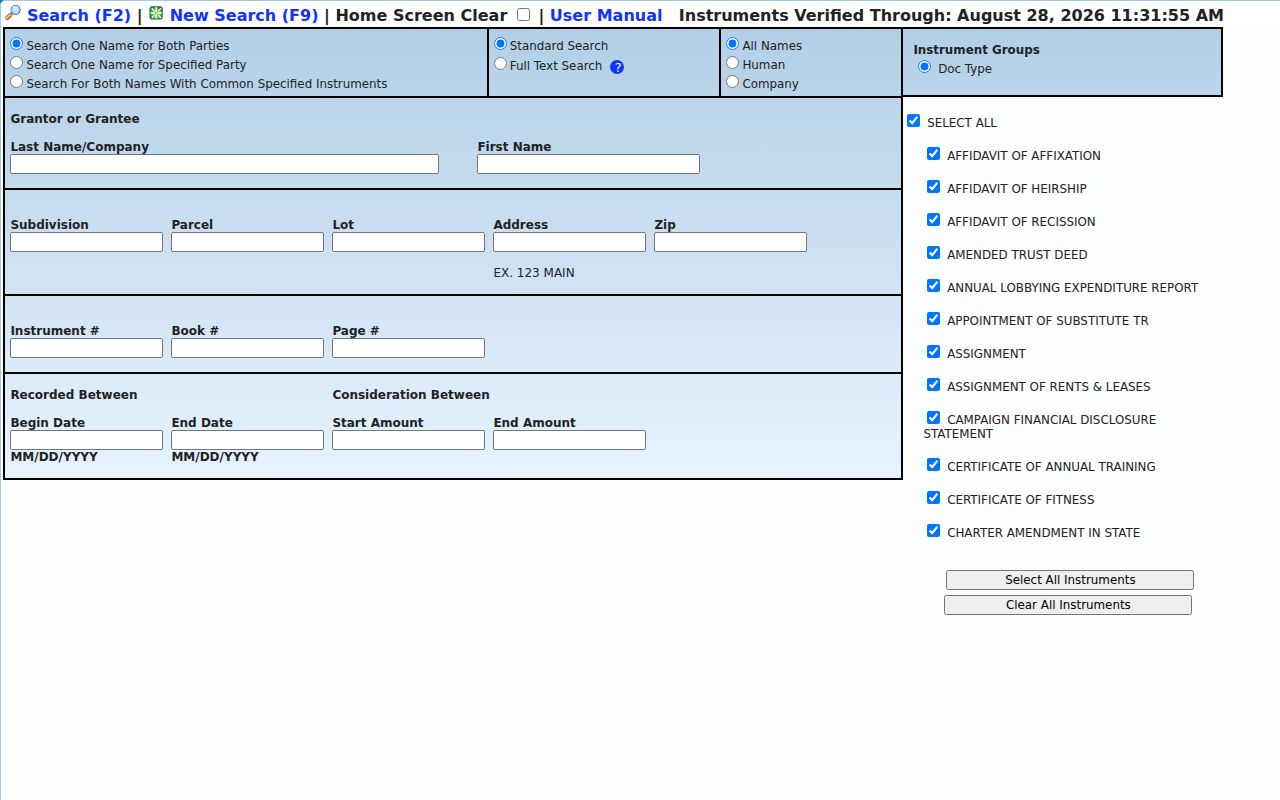
The Register of Deeds search accepts party names, parcel, lot, subdivision, address, ZIP, document number, book/page, date range, consideration range, and document-type controls. Its instrument groups include deeds, trust deeds, liens, plats, releases, UCC filings, and affidavits. For a specific Collierville address, first use the current parcel detail and then save the current deed’s parties, recording date, instrument number, book/page, consideration, and legal description. Search the seller as an earlier grantee to move back one transfer at a time.
There is no published single oldest online year for all Shelby deeds. The Register’s archive pages instead report collection-specific ranges, and older records, index books, images, or certified copies may require an office or Archives visit. The live screen reports instruments verified through April 20, 2026, which is a current-screen status, not a historical coverage date.
The Register live lookup shows the address, parcel, party, and instrument controls used for that manual chain.
Not every recorded document includes the city or ZIP, and chain-of-title links are not guaranteed. Parcel, subdivision, lot, legal description, and a narrow date range help when a street search does not bring up an expected transfer.
Note: The Register’s free Property Fraud Alert can notify a subscriber when a document is filed under a person’s or business’s name, but it is not title insurance.
Define Collierville Address Terms
A precise term prevents an address record from being read too broadly. In a Collierville street directory search, the physical place, tax correspondence address, and recording description may all be different fields. The terms below are the useful anchors when a modern street name is missing from an older instrument.
- Parcel
- A taxable tract identified by the county. It connects assessment information to the map and may lead to recorded transfers.
- Situs address
- The physical property location used by assessor, GIS, permit, and map records. It is not necessarily the owner’s mailing address.
- Plat
- A recorded map that can show lots, roads, easements, subdivision names, and adjoining parcel clues.
- Criss-cross directory
- A historical street-and-number section that can point from an address to a household or business name for that edition.
A legal description uses lot, block, subdivision, metes-and-bounds, plat, or parcel identifiers. It is the stronger anchor when a road name, direction, or house number changed over time.
Check Collierville Street Projects
Property history can add a Town-held layer to the Collierville street directory. The Town says Development can research past approval histories for buildings and uses, including building permits, inspection records, variances, and conditional-use permits. The Collierville Permit & Application Center is the documented application route. Its accessible official page did not reveal a full public search form, so an address-based project history is the supported use, not an assumed name search.
For open zoning or code matters, use the Town’s public-records policy and describe the address, date range, record type, and the responsive office. The Town Clerk is the primary coordinator for records outside police, fire, court, and school systems. A request can be checked for Tennessee citizenship, specificity, and whether the Town is the custodian. The permit custodian may also change with annexation date.
Use Collierville Voter Address Clues
GoVoteTN Search By Address accepts a street address and ZIP, while Tennessee’s other public registration lookup requires county, first name, last name, birth month, and birth year. Neither public tool produces a list of everyone on a Collierville street. A visible voter result is limited to a registered voter’s listed legal residence and related registration information at the data date. It does not show all household members, establish ownership, or prove that an inactive record still reflects a current residence.
For an official county file request, contact the Shelby County Election Commission about its current form, lawful use, format, and production-cost estimate. Tennessee law excludes Social Security numbers, driver-license or state ID data, and protected address information from public voter records. Safe at Home participants appear in the statewide list by participant ID only.
Note: A public voter result identifies a registered voter at a data date, not every person associated with the property.
Find a Historic Collierville Street Directory
A historic street entry is a date-stamped clue, not a current roster. Memphis Public Libraries documents city directories from 1849 to 1994 and suburban directories from 1964 to 1994. Cataloged Memphis Suburban editions for 1971, 1972, 1975, 1989, and 1991 explicitly include Collierville. Search both the alphabetic name section and the street-and-number section, test directional prefixes and abbreviated suffixes, and compare adjacent entries. Exact Collierville reverse-directory call numbers should be confirmed with the Memphis/Shelby County Room.
The collections themselves and how to read an edition are addressed on the Collierville city directory page. For a street question, use a directory entry after the parcel and deed work has established the relevant address and year. The Memphis Public Libraries local-history collection is the published regional starting point.
Place a Collierville Street Address
A Collierville ZIP or mailing city does not establish that an address lies inside the incorporated Town. The Town describes unincorporated land inside its Urban Growth Boundary as the Collierville Reserve Area. Its annexation history lists changes in 2012, 2016, 2017, 2019, 2020, and 2022, and says Building and Code inspection services begin on the effective annexation date. An older permit may therefore be held through a different county or Town process even though the mailing city now reads Collierville.
Use the Town annexation records with the Collierville map gallery, a plat, and Register GIS. No authoritative Collierville street-renumbering year was located. When an older address fails, compare the old street label, nearby intersections, subdivision or lot, and legal description rather than declaring a renumbering.
Note: A Collierville mailing address can predate annexation, so check current Town custody against the date of the requested record.
Limit a Collierville Street Directory Search
A street directory can connect public parcels, recorded instruments, historic printed entries, and limited voter information. It cannot turn those sources into a complete list of everyone who lives on a street. Owner mailing addresses can belong to a business, trust, agent, or an out-of-area owner. Directory entries can be incomplete, use abbreviations, or reflect a household only in that edition. Permit and code records have their own release rules, and protected addresses remain protected.
Use the record chain for family history, property questions, estate work, civic research, or checking a transaction. Ask the office that holds the record to verify a result, especially when an index, map, or historic source conflicts with a recorded document.
Lawful use. Collierville address records are for personal, lawful research. Do not use an address trail to stalk, harass, intimidate, or harm any person.